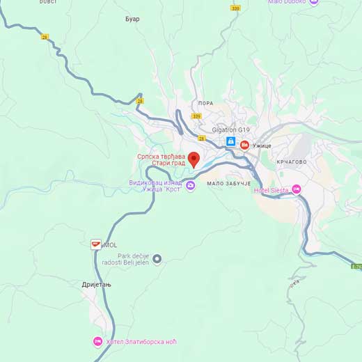
Medieval town Užice, Užice Municipality, Ras administrative county
MEDIEVAL TOWN UŽICE
Protected cultural monument of great significance, listed under SK 367 in the Central registry of the Republic Institute for the protection of cultural monuments
Medieval town Užice,Municipality, Ras administrative county
Where is it located?
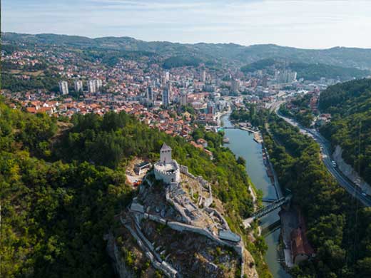
Užice town is built on a high, rocky slope on the left bank of Đetinja. The ridge nearly cuts into the river bed of Đetinja where the river leaves the gorge and continues its flow through a flat plain. Đetinja runs around the ridge slopes up to 50 meters high from three sides, west, south and east, making the town inaccessible. The only access to the city was via north.
History:
It is not known exactly when the town was built, most probably during the second half of the 14th century when many fortresses in Serbia were built or rebuilt. The build is associated with the lords Vojislav and Altoman Vojinović who wanted to protect their seat in Užice and secure the caravan road in Đetinja valley, connecting Morava plain with the Adriatic Sea and Venetian Republic.
It was first mentioned in sources in late 14th century, when it was ruled by župan Nikola Altomanić. In 1373, župan was imprisoned and held captive by king Lazar Hrebeljanović and Bosnian ban Tvrtko. Nikola Altomanić was then blinded and his lands were divided amongst victors.
 The town was destroyed and rebuilt on many occasions. The great renovation and rebuild was done in 1478, then during Austro-Turkish wars in 1688, and then again in 1737-1839.
Although historical sources do not list many data, it is known that between 1737 and 1862, when it was finally liberated, the town was intermittently ruled by the Serbs, Austrians and Turks. After the Turks left, in 1862, the fort was mined and disabled for further usage according to the contract stipulations.
Archaeological research of the fortress was done under the auspices of the Institute for the protection of cultural monuments Kraljevo between 1973 and mid-eighties. The town is almost completely researched. At the same time, the ramparts and the edifices of upper and middle town as well as the walls of the fortification towards the Water tower were conserved and restored.
The great renovation started in 2017 in order for the Old town to obtain its former glory.
In late 2023, the works on renovating the fortress were continued, supported by the City of Užice and European union programme „EU Pro Plus“. The complete reconstruction of Water tower, as well as the improvement of the existing tourist infrastructure, is planned, on order to open up the town for the public.
Description:
The data on Užice town, as well as the drawings of the town, were discovered in Vienna archives by Marko Popović. These data helped to renew the fort faithfully, the way it used to look.
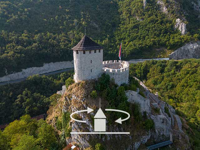
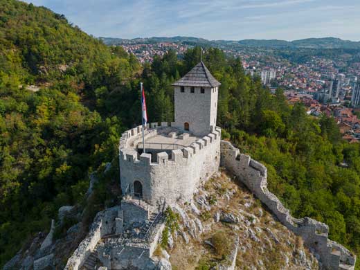
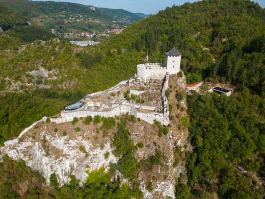
The fort was built in such a way that the base of the rampart was adjusting to the terrain that dictated the direction of the walls. Therefore, the foundation is of irregular, elongated shape. The highest part of the hill contains the small town, isolated and protected by the Donjon tower. The second, lower part of the town is the middle town, from which two ramparts flow down all the way to river Đetinja, where on its very bank the Water tower, which enabled the water supply is located.
The upper town or the citadel is actually a smaller fortification of oval shape with protruded semi-circular tower on the northeast, dominating the environment. The inner space is hardly 16m long and 11 m wide. The entrance to the citadel on the southwest side was 1,20m wide. Massive ramparts encompassing the very tip of the ridge are built of crushed stone bound by lime mortar, 1,80-2,10 m thick. The preserved height was 4-6 m on the outer side and only 3 meters in the inside court. The ramparts had a walking path and built prongs.
 On the entrance to the tower, there is a built-in stairway. Next to it is a smaller room with semi-circular dome and next to it two rectangular casemates, vaulted, above which there was an earthen embankment that represented a cannon platform.
Archaeological research revealed a well-cistern built into the rock.
Middle part of the fortress is of rectangular shape, as dictated by the configuration of the terrain. It surrounds the citadel with ramparts in such a way that only the main tower remains protruded. On the corners, there used to stand towers, main gate being next to one of them. Today this is the least preserved part of the fort.
The inside of the middle town was filled with numerous edifices meant for the accommodation of crew, equipment, and food. One drawing, left by Felix Kanitz, represents a two-storey building. From the ground floor of this building one could enter the lagums – two elongated rooms built into the rock and connected with the hallway, most probably representing dungeons.
The biggest edifice of the middle town is actually a complex towards the citadel, made of staircase and two rooms. The edifice probably had two floors and the staircase was covered, as suggested by the traces of arch-bearing pilasters.
On the east side, there are preserved traces of two more edifices, built on flat platforms. They probably had upper constructions made of wood, as suggested by preserved drawings.
Along the southern rampart there are the remains of eight separate rooms, of unclear purpose. One of them may have been a workshop for producing gunpowder that was evidently being produced in Užice in late 16th century.
The ramparts that cascaded down from the upper town were 1-1.5m-2m wide, since they were on a cliff and could not be approached. Here as well the ramparts were built of the crushed stone bound by lime mortar, without foundations, built on the rock. In some places, there were platforms placed alongside the ramparts, because it was impossible to build walking paths. The platforms were closed off with walls towards the outer side, likely with prongs, and later may have contained loopholes.
Where northeast and southeast rampart meet, there used to be an eastern tower, as testified by visual sources, but it disappeared in later iterations.
Lower town, the lowest point of Užice town spreads from the city gates in the south all the way to Water tower connected to the river. This elongated space used ramparts to protect the exit to the river in order to secure water supply during sieges. The rampart is built of crushed stone following the edge of the cliff determining the direction of the walls. In this inaccessible part, the rampart is hardly 1,2 m thick.
The Water tower was semi-circular in the base, over 20 metres high, divided into 8 floors with wooden constructions. The walls of the tower were massive, between 2 and 3 meters thick. They were built in the same way as the ramparts, the outer layer was under a mild incline and the upper floors contained one or more narrow windows.
The Lower town appears to have contained two more edifices, based on discovered remains. One of them is supposed to have been wheat barn.
In front of the city gates there was a trench over which there was a wooden bridge. Approaching the bridge, there used to be a cobblestone road next to the ridge. The remnants of the sub wall and cobblestone have been preserved.
Dating:
Užice town was built in the 14th century and used until the mid-19 century, more precisely until 1862, when the fortress was mined, according to the contract with the Turks.
Folk belief, legends:
Serbian nobleman Altoman was the lord of Užice town and its surroundings. He had a significant spot among the lords of emperor Dušan and ruled the province near Dubrovnik in mid-14th century. He also owned lands in Gruža. It is known that, during his wedding ceremony in 1347, he asked to hire ships from Dubrovnik, with the approval of Serbian emperor Dušan. Towards the end of his life, he was awarded the title of Grand Župan, as testified by the tombstone of his wife Ratoslava.His son Nikola Altomanović was born in 1348 and as early as 1367 he is mentioned as the lord of Rudnik, because he inherited the lands from his uncle, Vojislav Vojinović. The young župan became the strongest landlord of the former Serbian empire after the defeat of Serbian army at Marica. He held the areas from Rudnik and Kosovo up to the Coastal area. He ran the coastal areas of Dračevica, Konavli and Trebinje. His aggressive politics endangered the surrounding lords. At one moment, he made the mistake of asking for the alliance with the Venetians instead of King of Hungary. The King had Nikola Altomanović assassinated, in alliance with king Lazar and Bosnian ban Tvrtko, with the help of corruptible lords.
Јулка Кузмановић Цветковићархеолошкиња