
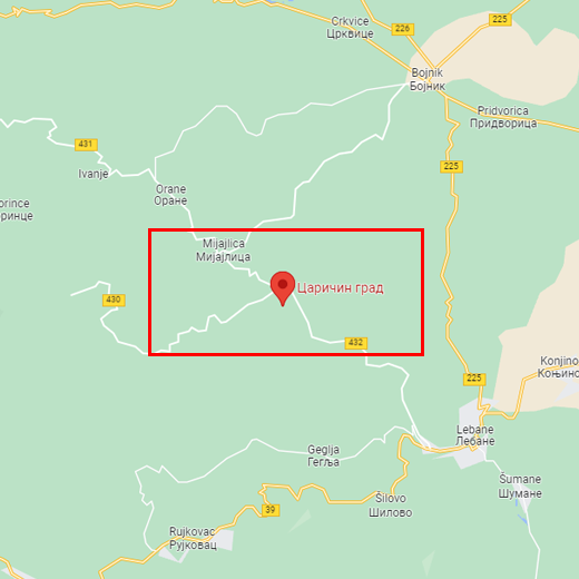
Caričin grad, Prekopčelica village, Lebane municipality
CARIČIN GRAD
Protected cultural monument of great significance, listed as AN 24 with the Republic Institute for the protection of monuments of cultural heritage.
CARIČIN GRAD Lebane municipality
Where is it
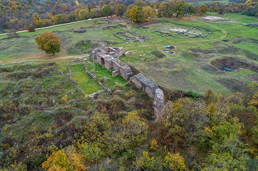
Caričin grad is located at the foot of Radan mountain, on an elevated plateau between Caričinska and Svinjarička rivers, next to the village of Prekopčelica. It is 30 km southwest from Leskovac and 9 km from Lebane, the nearest modern settlement.
Research
Archeological research of Caričin grad begun in 1912, under the leadership of Professor Vladimir Petković from the Faculty of Philosophy from Belgrade. Between 1936 and 1940 the research was conducted under the auspices of Serbian Royal Academy and the University of Belgrade. During the campaign, they discovered the Acropolis complex, ramparts, towers, eastern gate, episcopal basilica with baptistery, and episcopal palace. The research was interrupted by the war, but continued in 1947 and lasted until 1970, under the Archaeological Institute from Belgrade. That research, with some interruptions, continues to this very day. Since 1978 the team of researchers was joined by the French archaeological school from Rome.
Dating
According to the researchers, Caričin grad is in fact Justiniana Prima, the endowment of Byzantine emperor Justinian I (527-565).
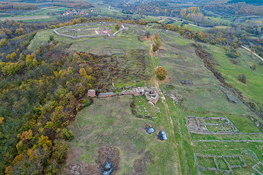
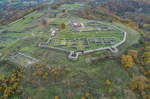
Description
Caričin grad was built with a special purpose, away from important communication lines, surrounded with ramparts with towers, while the southern, lowest part was surrounded with water trench. The city could be entered from south or east side, through monumental gates protected with towers. There are three smaller forts nearby, protecting the city.
Emperor Justinian I, wanting to mark the place of his birth, built the city called Justiniana Prima, an important seat of the church. The new capital was elevated to the rank of an archbishopric, with jurisdiction over north Ilyricum. According to its purpose, the city was built of brick and stone and the buildings decorated with marble and mosaics.
The space inside the walls, approximately 10 hectares, is divided into three parts. The highest plateau has the Acropolis, of irregular polygonal shape about 100 x 100 m. It is surrounded with a rampart with horseshoe shaped towers on both sides of the eastern gate and rectangular towers on the north rampart plateau. A street that runs in the direction northeast-southwest divided the Acropolis into two parts: on the northern side there is a complex consisting of three large objects that are understood to be episcopal court with accompanying facilities. On the southern side there is an episcopal basilica 64 m long and 22 m wide, three-naval with three apses, with a narthex and an atrium that includes a water reservoir. The lateral naves are separated from the naos with two rows of five decorated pillars each. The floors of the central nave and narthex were covered in mosaics, somewhat preserved, and the rest of the floor space was covered in bricks. The atrium held a large water reservoir cut inside the rock. The walls of the atrium were decorated with glass mosaics. Next to the basilica, on the southern side, a monumental baptistery was built, with almost square basis of 17 m in length. In the middle room there were four pillars supporting a dome above the baptism pool. The floors were also covered in mosaics.
The Upper town
испод Акропоља, заузима благу падину која се спушта ка ка истоку и југу, захвата простор дужине око 300м и ширине 230м у северном делу и око 100 м на јужном делу. Бедем који се јасно назире на терену прати северну линију греде. У овом делу су истражене источна и јужна капија и делови бедема уз капије. На бедему се издваја кула на југозападном углу малтерисана водонепропустивим малтером која је служила као резервоар за воду до којег је водио аквадукт. Источна капија је са обе стране има правоугаоне куле, јужна капија кроз коју је ишао саобраћај је фланкирана истуреним, правоугаоним кулама.
There are numerous objects around the square. On the southwest there was a house with arcades 17,50х15,50 m, with two floors. Another large edifice is on the south.
Another important object is a basilica with the crypt, dimensions 35х15,5 m. Basilica is three-naval with lateral naves separated by columns while the crypt had massive walls and was composed of one central and two lateral spaces with semi-circular vaults.
Next to the southern street there was a cross-shaped church, dimensions 29,50х17,50 m, poorly preserved.
Under the Acropolis, there is another smaller three-naval basilica with an open portico, whose length is 24,80 m.
South of the basilica there is an edifice called villa urbana, length 25 and width 22 m, composed of the row of separate spaces.
One of the more significant objects is principia, seat of the military command. It is a three-naval edifice with banquet hall, length 37 and width 18,80 m, located along the south and west rampart. 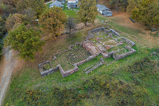
Lower town
is formed south of the upper town and runs along a flat, elongated plateau about 220 m in length and 100-120 m width. It is surrounded with ramparts with towers and on the southern, easily accessible side, it has a deep trench. During the research, south and east gate were discovered, similar in bases, both protected with protruded rectangular towers. The west part of southern rampart is the best researched part of the fortification, as well as the southwestern tower with aqueduct. The aqueduct went along the western rampart to the large cistern in the Lower town and the southwestern tower in the Upper town.
The east street of the Lower town was thoroughly researched, and partly the south one dividing the town into two units. The driveway of the east street is 7.5 m wide and a portico made of large stone blocks runs along it. There were sewers underneath both streets.
Right next to the south street, along the north portico of the east street there was a basilica of irregular basis. The basilica has two long naves 18 and 19 m long, 5.7 and 5 m wide, with semi-circular apses on the east and vestibule on the west.
The Sub-town
јwas formed in the plains under the city, covering almost 20 hectares, inhabited by people who were in charge of producing everything that the city may need, primarily food. They performed agriculture and cattle herding, as well as crafts. At the banks of Svinjarička river, brick furnaces were discovered, meaning the bricks were produced there. Outside the city limits, thermal baths were researched, next to the east gate of the Lower town there is a tricohnal basilica and a single-nave church on the south plateau. On Caričina river there are the remains of a dam- bridge whose walls are 4 m thick and that closes off the river flow. Above the dam there is a fortification of rectangular basis.
Folk lore and belief
There are numerous legends about Caričin grad. What is interesting is that they attribute the city to the Empress Theodora and not the Emperor Justinian. One of the legends says that the enormous city was built by an emperor whose name had been forgotten. As it was built on a place without running water, the emperor offered his daughter's hand to whoever could bring the water into the city. According to the lore, the water was brought by a wise but poor swineherd, straight from the Radan mountain. The emperor hated for his daughter to be wed to a swineherd so he broke his promise. The daughter, disrespecting the father, fled with the handsome swineherd. The emperor sent a chase after the fugitives, who executed them both. That is why God punished the father and flattened the city to the ground.
Јулка Кузмановић Цветковићархеолошкиња