Diana-Karataš, Roman and Byzantine fort, Kladovo municipality, Bor District
Dianna Fotress
Protected cultural monument of extraordinary significance, listed as AN 103 with the Republic Institute for the protection of monuments of cultural heritage.
Diana FortressKladovo municipality, Bor District
Where is it
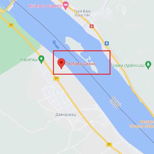
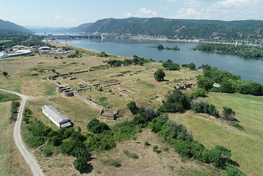
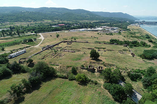
Diana Fortress is built on a plateau on a high rock above the Danube, in the vicinity of Sip village, right under the Hydro plant Djerdap I. Thanks to its natural position, it was not flooded during the Djerdap accumulation. Conserved and partially renewed ramparts and remains of the Diana fortress are today located next to the contemporary road Belgrade-Tekija-Kladovo, on a plateau above the Danube called Karataš (the Black stone).
Research
The first data on the fortress was recorded by F. Kaniz, Austrian painter, in the late 19th century. The first research was performed in 1964, and then in 1971. The big systemic research was begun in 1978 and by 2012 the National museum from Belgrade managed to explore almost one third of the fortress as well as the part of immediate surroundings – settlement and necropolis. The Diana fortress is one of the most complex researched objects in upper Moesian limes.
History
The oldest fortification on Karataš is dated in the 1st century, when the first Roman troops arrived in the Danube area. Stone fortification, Diana, was built during the reign of the emperor Trajan, 100-101 AD, and the canal was dug at the same time in order to ensure the safe passage by the Danube. In this area, the Danube has numerous vortexes and whirlpools and underwater rocks, that make sailing it difficult, so the emperor Trajan built a canal parallel to the Danube during his preparations to attack the Dacians. Diana was originally a castrum with dimensions 100 х 200m, with retracted towers on its ramparts. The castrum obtained its final look in the late 3rd and early 4th century, when the ramparts were given protruding towers towards the Danube, in order to protect a part of the shore.
That this was, indeed, fortress Diana was confirmed by the discovery of sacrificial base with an inscription to the Egyptian god Thoth, that states the full name of the place: STATIO CATARACTUM DIANA. Diana was the Roman goddess of war, and the castrum was named after her.
The fortress was partially burned by the Goths in late 4th century, destroyed by the Huns in mid-5th century but renewed in early 6th century by the Byzantine emperor Justinian. Then the fortress gained a fortified annex, thus enlarging the entire area to almost 3 acres.
In the late 5th century the fortress was finally destroyed during the Avar and Slavic invasions to the Balkans.
Description
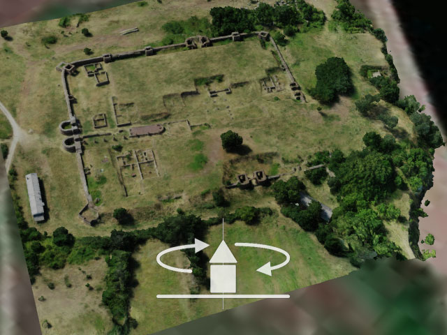
Diana fortress was one of the largest Roman auxiliary castra on the Danube limes. It was an important military position and a crossroads of river and dryland roads for six centuries.
Archeologically researched fortress with a conserved and, up to certain height reconstructed, stone ramparts, with renewed brick-built edifices, today represents a tourist attraction and a place to observe an excellent example of Roman military architecture.
The fortress is shaped as a rectangle with rounded corners, with dimensions 140х136 m, with shorter south and north side, towers on the corners and gates on all four sides fortified with semi-circular towers. Only on the northern side towards the Danube the towers were square. The ramparts had two additional towers on the north and south side, with other three on east and west. In total, the stone ramparts had 19 inner towers. All four main gates were discovered and presented: porta praetoria (main gate), porta decumana (southern), porta principalis sinistra and dextra (left and right gate). The towers of the main gate, on the southern side, were somewhat bigger and with stronger walls because Diana expected biggest threats from the land. These two towers, partially reconstructed, continue to dominate the rampart and protect the main entrance to the fort to this day.
Apart from the remains of the rampart with gates and towers, the research also discovered one of the two main streets, and in the central part, the remains of the principium (military command). Along the northern, main gate, food storage was discovered (horeum), along the southern gate (porta decumana) there used to be military barracks (contubernia), in the north-western part there was a public bath (balneum) with a drainage canal under the ramparts. On the inside of the fortification, an edifice with an apse that had floor heating (hipocaust), was discovered, while another edifice had running water and pools for water preservation with lead and ceramic pipes.
Next to this strategically important building a big civilian settlement developed, with a dock, that is mentioned in early byzantine sources as the town Zanes. Outside the ramparts, a sanctuary was discovered, as well as a part of a necropolis and a part of a bigger settlement west from the military camp. Based on the research results, main roads and necropolises were located, and the size of the settlement could be assumed.
Julka Kuzmanović Cvetkovićarcheologist